BEFORE THE WESTERN WASHINGTON GROWTH
TOWN OF FRIDAY HARBOR, et al., )
) No. 99-2-0010c
Petitioners, )
) REPLY BRIEF IN SUPPORT OF
v. ) FINDINGS OF INVALIDITY AND
) NONCOMPLIANCE AND IN
SAN JUAN COUNTY, ) OPPOSITION TO COUNTY'S
Respondent ) MOTION FOR COMPLIANCE
) FOR HEARING ON
) MARCH 6-7, 2001
____________________________________
)
MICHAEL DURLAND, et al, ) No. 00-2-0062c
Petitioners )
)
v. )
)
SAN JUAN COUNTY, )
Respondent )
)
and )
)
OPAL )
Intervenor )
)
Jointly submitted by:
|
Participant/Petitioner Maile Johnson La Porte Road Box 125 Orcas, Washington 98280 (360)376-5298 Fax (360)376-5298** |
Petitioner Lynn Bahrych P.O. Box 160 Shaw Island, WA 98260 360-428-2396 Fax 360-428-3196 |
Intervenor/Petitioner Joe Symons 3222 Point Lawrence Road Olga, WA 98279 360-376-4549 Fax: 360-376-2626 |
Note: This reply brief does not discuss the issue of whether a property owner who has a guest house should or should not be able to contstruct a main house. Petitioners have responded to that issue via "Petitioner's Response to San Juan County's Petition for Declaratory Ruling" on February 14, 2001. Consequently, parties addressing this issue, admitted by the Board as intervenors on Februrary 21, 2001, will not be served with this reply brief, per advice of Shellie Burnham, Administrative Officer, WWGMHB, pursuant to the inclusion of this notice.
Table of Contents
1. SJC fails to rebut Petitioners' arguments and ignores the opportunity to respond to Petitioners' Brief. *
2. SJC admits and Petitioners have demonstrated that the CP promotes sprawl.
3. SJC argues unpersuasively that weak and ineffective mechanisms provide substantial protection of rural character and resources.
*4. SJC fails to rebut Petitioners' case that the CP fails to provide a variety of rural densities. SJC's claim that its 2000 Amendments appropriately provide a variety of rural densities (section V, #6, pg 41) is unsupported by its arguments.
*5. There is no basis for presuming that a significant population shift will occur from rural to urban areas.
*6. SJC asserts (V, 10) that "aspects of rural character have been studied and considered", quietly omitting that the key density "aspect" was never studied by the BOCC.
*7. SJC claims that the County "has met and exceeded the public participation standards required by the Act," despite failing to notify the public of the true density implications of the CP during the remand period.
*8. Relief Sought
*
1. SJC fails to rebut Petitioners' arguments and ignores the opportunity to respond to Petitioners' Brief.
Petitioners' "Brief in Support of Findings of Invalidity and Noncompliance and in Opposition to County's Motion for Compliance for Hearing on March 6-7, 2001", dated January 31, 2001 (hereinafter Petitioners' 1/31 Brief) presents authorities, facts, and stipulations and admissions by San Juan County (hereinafter SJC), that SJC has enacted a CP that encourages sprawl and fails to provide a variety of rural densities or to protect rural character and to limit rural development. The "County’s Brief for March 6,7, 2001 Compliance Hearing and Hearing on the Merits" (hereafter SJC Brief) is not responsive. SJC has made no reply to the authorities, facts and analysis in Petitioners' 1/31 Brief. Of approximately 20 pages devoted to density and rural character issues in the SJC Brief, over 5 pages repeat verbatim text from the "County’s Brief in Support of Compliance on Rural Densities and Guest Houses", dated 12 November 2000, neglecting even to acknowledge Petitioners' response to that text. For brevity, Petitioners decline to repeat their unanswered arguments, and respectfully request the Board to read their Brief and to weigh the County's silences against it for its failure to rebut Petitioners' authorities, facts and analyses which conclude that the SJC CP encourages sprawl and fails to provide a variety of rural densities, to protect rural character and to conserve and buffer resource lands.
SJC repeats conclusory, unsupported or non-sequitur claims that serve little purpose other than obfuscation. For example, (SJC Brief pg 35, line 7) "[t]he Act doesn’t require that the County stop growth. . . " Petitioners have never made that assertion. SJC Brief assures the Board that it has assured a "variegated landscape" although it is a variegated rural density that is the requirement of the Act. (SJC Brief pg 34 line 25, pg 44 line 23). Wrapping themselves in the Vision Statement flag, SJC at pg 35, lines 16-21, taken verbatim from their November compliance brief, evokes sentiments of rural ruggedness in claiming the CP was designed to provide land and housing for a whole host of dirty-hands and proud heart types ("laborers, farmers, landscapers and others") along with their parents and children. Yet nowhere does SJC actually reference where in the Vision Statement their policies are linked, nor indeed does it state what policies it has constructed to achieve these noble ends. To be more than hot air, fire needs form and substance. Wendy’s put this succinctly when they asked "Where’s the beef?"
It is far more likely that SJC's own density policies will drive those individuals out of the County rather than Petitioners' GMA arguments regarding rural character. Aside from the repeated failure of SJC to adequately address affordable housing, well described by John Campbell and thankfully well received by the Board, SJC has failed utterly to describe, much less "evaluate, discuss, study, analyze and consider" the tax implications of its density position (see item #6 below). Many studies have shown that residential development is not self-supporting fiscally, including the "Cost of Community Services" study produced for Skagit County in 1997 by the American Farmland Trust, which noted: "Residential development did not pay for itself, requiring $1.25 in services for every dolar of revenue generated." (pg 6. Exhibit A)
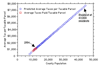
A 1995 study by Amanda Azous (included as Exhibit 3 to Petitioner Bahrych et.al. Reply Brief, February 26, 2001) discussed the tax implications of population growth for San Juan County. The study carefully details assumptions about the relationship between population growth compared to capital facilities and governmental services growth. Ms. Azous notes that the report she developed, a graph of which is presented below, "shows that average taxes paid on a taxable parcel would be expected to increase roughly six times 1994 levels at buildout, predicted to be somewhere around 43,000 people."
Predicted Average Taxes Paid on a Taxable Parcel.
(San Juan County Tax Analysis, Amanda Azous, 1995)
When challenged by Petitioners to show how it has sheltered its rural character, landscape and economy from devastating conversion pressures, predicted in the Socio-Economic Report on related communities, which would transform and eviscerate its rural character and economy, SJC asserts: "The report was considered, and policies adopted in an attempt to prevent San Juan County from becoming another rural museum piece". (SJC Brief pg 35, line 14.) While this sounds colorful, the record shows the study was ignored–SJC offers neither here, nor anywhere, details as to the policies it claims were adopted.
In summary, the report's recommendations are:
1.) Reduce the rate of development through a point-scored cap or another similar growth rate reduction system.
2.) Decrease the level of capacity at which buildout is reached.
3.) Create a vital, affordable housing market for long-term, permanent residents with perpetual deed restrictions; and do the same for seasonal workers.
4.) Diversify the economic base beyond tourism and construction using multiple strategies including marketing made-in-the-community products.
5.) Use the slower rate of growth to increase the rate of acquisition of key parcels, through the development and implementation of a unified greenspace/open space plan. Use this in conjunction with TDR's and infill mechanisms to focus growth away from the countryside and concentrate it within urban growth boundaries.
6.) Establish a peak carrying capacity for the area using both objective and subjective criteria.
There are a number of ways to accomplish these tasks. What is important is that no matter how they are done, we believe they must be done if these types of communities are to remain vibrant and retain a significant amount of what made them desirable in the first place. The sooner they are done, the better.
Conclusion, pages 31, 32 of Report. (##230728-230830)
The Planning Department transmitted the report to SJC Board of County Commissioners, highlighting it with an expression of Planning Staff concern, and including the following comments:
The San Juans appear to be headed the direction of Aspen and Nantucket. The lessons of those communities seem to be:
(5) It is possible to retain many aspects of rural character over time while providing for substantially more population and development, provided that this development is strictly limited to tightly-controlled growth areas developed at urban densities. The European model of development, in which densely developed villages are surrounded by rural farmland and forest, clearly illustrates this potential.. . .
(7) The rural landscape will only be available to those of modest means on public land or on land legally constrained to rural activities and patterns of development. Rural land and character will only be available if substantial amounts of rural land are retained in public ownership and management or if government control manipulates the private market to preserve rural character by substantially restricting the options of private property owners.
SJC Planning Staff Report, May 25, 2000, Rural and Resort Communities Study, pg 3-4. (Staff report and relevant sections from the Socio-Economic Report were provided to the Board as Exhibit 17 to Symons Brief, October, 2000. No index numbers were available from SJC at that time.)
Rather than reducing density and capping development, SJC's actions since receiving this report have headed in the opposite direction, by seeking to redesignate over 1000 acres of resource land to rural designation; by adopting a resolution to reconsider redesignation of all resource lands, with commissioners announcing their intention to dismantle them; by defending all remnants of its 1979 density plan by enacting numerous density bonuses; and by defending, by appealing to Superior Court, invalidation of its new (since 1998) policy of allowing every parcel to build two residences (both of which can be rented, one for transient use) to house two unrelated families, all of which further erode rural character. While the County expresses concern regarding availability of affordable housing, it is poor planning indeed to permit, even encourage, rural sprawl in hopes it might somehow provide affordable housing–GMA does not sanctify a plan in which affordable housing trumps containment of sprawl. Policies preserving rural character and low density rural lands can, and must, go hand-in-hand with support for affordable housing.
Eagle Lake argues for the continued subdivision to 5 acre parcels–when there are numerous much smaller parcels that are vacant–on the grounds that this will help to provide housing for people of all incomes. (Eagle Lake Brief pg 8, line s 6-7). A 5 acre parcel of land in the Eagle Lake development costs between $105,000 and $180,000, improved only with water, septic and roads.
The Brief submitted by Intervenor OPAL Community Land Trust states that "[n]ot even middle-income residents could afford a 5-acres lot selling for $90,000, a common price for an inland parcel throughout the county" and "[t]he average wage for a working islander is $20,000. A household with an income of $20,000 can afford a mortgage of about $80,000 (7% mortgage, $5,000 down). There is clearly no way that an average wage earner could afford a home on the open market when average land prices for a lot are higher than the mortgage they can attain." (OPAL Brief pg 10, line 10 and pg 6, lines 10-13). OPAL's Brief further suggests that even the proposed Rural ResidentialClusters, which would allow affordable housing to be clustered at a density of 1du/0.5 acres, would not be affordable unless far more than the permitted six houses could be built on the same site, sharing infrastructure costs. "To meet the demand for people already living on the islands and trying to do so affordably, we need parcels large enough to support clustered developments of 20 or more homes." (OPAL Brief, pg 5, lines 13-15. See also lines 1-7)
2. SJC admits and Petitioners have demonstrated that the CP promotes sprawl.
In an unsubstantiated and conclusory statement SJC asserts that "[t]he development and use patterns in the County's rural areas do not promote sprawl, so no written record of local circumstances is required." (SJC Brief pg 36 line 14) As set forth in Petitioners' 1/31 Brief, SJC has stipulated (#260166) that the CP permits an average rural density of 1 du/ 4.0 acres, without any density allowance for guesthouses–future or now known to exist–and SJC has admitted that density greater than 1 du/ 5 acres constitutes sprawl. ("[S]prawl represents suburban densities between 4 du/acre and 1 du/5 acres." SJC Brief dated November 13, 2000, page 16, lines 22-23).
The SJC Brief quotes (page 42) from Smith v Lewis, 98-2-0011c, FDO 3313, 3315 (Apri 5, 1999) language and ruling which sentence by sentence, Petitioners submit, require invalidation of the rural density designations of the SJC CP for its encouragement of sprawl and failure to afford a variety of rural densities. Petitioners' 1/31 Brief quoted and discussed this language (at pages 8 and 28, as well as in earlier briefs filed for the November 14, 2000 HOM) and presented facts and analysis of the SJC plan and local circumstances with regard to the issues raised in each sentence of the Board's order in Smith v. Lewis County, . SJC has chosen not to acknowledge or refute any of this. Petitioners specifically request the Board to read their Brief and weigh the County's silence against it on the central issue of rural density and sprawl.
The Board's ruling in Lewis County required:
Despite the flat denials or silence by SJC and Eagle Lake on this issue, this same quotation from Smith v. Lewis , id, is authority for the argument Petitioners have made that it is essential to average rural densities as part of the evaluation of the rural density plan and pattern. "Without the balance of lower, 1 to 10 and 1 to 20 densities, the extensive use of 1 to 5 and allowance of higher densities in areas of more intensive rural developments (AMIRDs) creates high average densities that do not comply with RCW 36.70A.070(5) and .030(14)." Smith v. Lewis, supra at 3313 and SJC Brief pg 42.. Petitioners' 1/31 Brief sets forth hypothetical situations showing that failure to ascertain actual density through evaluation of average parcel size allows a CP to masquerade sprawl as GMA-compliant rural development. (Petitioners' 1/31 Brief, pages 6 to 8). Repeating SJC's argument, Eagle Lake Development ("Eagle Lake") ignores the authorities cited by Petitioners and proposes that the only densities the Board should consider are those of parcels not yet created. (Eagle Lake Brief, pg 2, lines 21-25). This proposes an emasculation of GMA that would, in San Juan County's circumstances, render its mandates to preserve rural lands and character meaningless and unachievable.
This same quotation from Smith v. Lewis, id, (SJC Brief, pg 42) sets forth the CTED admonishment that densities of 1/10 acres and 1/20 acres predominate in the rural area. SJC is silent with regard to section 5 of Petitioners' 1/31 Brief, which shows in careful detail that CTED's admonishment means an average rural density of 1du/8 acres, while SJC has stipulated that its CP allows double that density, without including guesthouses. (#206166).
SJC’s Brief, page 50, lines 4-20, describes its CP data as "hypothetical" (which the American Heritage Dictionary defines as "existing only in concept and not in reality"), as if to imply that it might not be the basis for planning. SJC states "[I]n each rural land use district, the 2000 hypothetical buildout shows a significant reduction in sprawl..." To support that position, the Brief presents a table containing a number of land use designations (data taken from #260166), all but 2 of which are largely irrelevant to this discussion. The two relevant land use categories are "Rural Residential" and "Rural Farm Forest". Not mentioned by SJC is the data regarding the size of these 2 categories: combined, they represent 90% of the acreage, and 95% of both existing and "hypothetical"–meaning potential under the CP–parcels. Combined, the average existing parcel size is 1 du/5.16 acres and, at buildout, i.e., as defined by the CP, the average parcel size is 1 du/4.0 acres. (from #260166: 8605 [RR] + 48,848 [RFF] = 57453 rural acres out of 63616, or 90%. 4782 [RR]+ 9575 [RFF]=14357 parcels [CP] out of 15185, or 95% [CP]. 57453 acres / 14357 parcels=4, i.e., 1 du/4 acres [CP])
SJC would have the reader believe that "sprawl" has been significantly reduced from the 1998 CP, but the fact is that the 2000 CP is still defined by a very significant degree of sprawl. SJC has stipulated that the average rural parcel size under the 1998 plan was 1du/1.8 acres, a density held in Mason County to be per se urban. (#260166). We are told that "the County will be better off under the new plan than under the old plan" but that is like saying to the passengers of the Titanic, "we are only going to hit (hypothetically of course) a smaller iceberg."
3. SJC argues unpersuasively that weak and ineffective mechanisms provide substantial protection of rural character and resources.
SJC's list of local circumstances (SJC Brief pg 37-38) contains no data on water resources nor acknowledgement of the evidence in the record (Exhibit D to Petitioners' 1/31 Brief) of the extremely limited water resources in the county. SJCC §18.60.020 allows new development if the developer sinks a well that produces water at the well test draw. Allowing each new development to sink a well into an aquifer already being overdrawn is irrational and surely non-compliant. It likewise contains no data on sensitivity of habitat and wildlife. It reveals that SJC counts houses that are used for recreational use as vacant, regardless of how long they may be occupied. (¶4) It suggests the county has maintained its rural look because it consists of islands, (¶¶8 and 9) and it ignores Petitioner's 1/31 Brief which reminded readers that if San Juan county has a rural appearance today the overwhelmingly responsible reason is that only 45% of development allowed by the CP has occurred.
Citing the same programs, regulations and facts it has before, and which Petitioners' 1/31 Brief has shown to be of insignificant impact and marginal relevance, SJC asserts that it has protected its rural character with Land Bank acquisitions (a tiny 546 acres of land acquired in a full ten years of operation; County's Brief pg 44, line 3); the use of owner-optional or Land Bank-purchased conservation easements which SJC admits may not alter density of development at all, only placement of development (County's Brief on Compliance on Rural Densities and Guesthouses, page 11); ineffectual and largely inapplicable development regulations (76% of rural lands may have 30% of a parcel's area plus roads and driveways covered with impervious surfaces (SJCC §16.60.050 Table 6.2, fn 13 and fn 2, infra); so-called conservation design provisions which will not apply to 73% of parcels and development permitted by the CP in rural and resource lands (SJCC §18.70.060B(10), and pg 32, Petitioners' 1/31 Brief) and owner-optional and temporary current-use taxation programs (SJCC §16.50.800). SJC has not answered these challenges, although they were included in Petitioners' 1/31 Brief.
SJC argues in its Brief (pg 43 lines 17-22) that 8410 acres are held subject to conservation easements, but neglects to inform the reader as to how many of those include a relinquishment of development rights (hereinafter DRs). The document stating the figure of 8410 acres also reveals that these same acres are held within 338 parcels. #243453 We have no idea how many of the 338 parcels have extinguished DR’s. Even if they all extinguished at least one DR (an unrealistic assumption yet SJC offers no data here), this would represent retirement of about 1% of the total DR's described in the CP (#231432 shows 26,531 maximum development rights–as "du’s"–in SJC; 338 is 1.27% of 26,531). SJC argues (page 44, lines 2-9) that the Land Bank and the San Juan Preservation Trust are examples of innovative ways "in which the County provides a variety of densities, while at the same time attempting to satisfy Goal 6 of the Act, which is to protect private property rights." The total acres owned by both these institutions, cited by SJC, is 914 acres. This represents 0.8 % of the county (914 divided by 112,115 total county acreage, from #260166). Innovative, perhaps, but no blip on the radar screen–hardly worth emphasizing unless, one might conjecture, SJC has nothing of greater significance to offer.
SJC repeats its assertion that it has protected rural character and limited rural development by protecting critical areas, though Petitioners' 1/31 Brief pointed out that protection of critical areas is mandated by GMA, compliance with which mandate does not constitute compliance with the separate statutory mandates in GMA for conservation of rural character and containment of rural development.
Eagle Lake emphasizes the significance of the mandatory nature of the "conservation" subdividions design reqirements without once acknowledging Petitioners' caveat that they are utterly ineffectual under the facts here, namely: that the regulations operate only on new subdivision, that the county can develop at the OFM projected rate for 24 years without creating a single new parcel, that development and population could thus more than double, potentially seriously compromising or even extinguishing all groundwater supplies and all marine and terrestrial wildlife while the design regulations would never have operated at all. (See more complete discussion pages 32-33, Petitioners' 1/31 Brief).
Eagle Lake unconvincingly proposes that rural character is effectively conserved by subdivision and design regulations which are inapplicable to 73% of development in rural and resource lands and by SJC's limitations on impervious surfaces. It misreads the latter provisions, describing them as 'stringent" and as limiting impervious surfaces "to 10% in most rural designations". (Eagle Lake Brief pg 6 lines 13-18.) In fact, in RFF, which SJC stipulates (#260166) is 76% of rural land, impervious surfaces are limited to 30%. SJCC §18.60.050, Table 6.2, fn 13.
4. SJC fails to rebut Petitioners' case that the CP fails to provide a variety of rural densities. SJC's claim that its 2000 Amendments appropriately provide a variety of rural densities (section V, #6, pg 41) is unsupported by its arguments.
As well as failing to rebut Petitioners' analysis and authorities that average rural parcel size is relevant to evaluation of density and that an average rural area density of 1du/4.0 acres is sprawl, SJC fails to address Petitioners' 1/31 Brief on the adequacy of the variety of rural densities afforded by the plan. SJC's Brief sets forth in a chart at page 43 its third version in as many briefs of the range of rural densities afforded under the CP. The chart lists six density (du/acre) designations: 1/5, 1/10, 1/15, 1/20, 1/40, and 1/zero.
Petitioners' 1/31 Brief discusses the range of density afforded by the CP as offering only three density designations, namely one du to 5 acres, one to 10 acres and one to 15 acres, and concludes that the range of variety afforded thereby is illusory and inadequate. Having obtained new information from the SJC Brief and from the GIS database, Petitioners' are confirmed that these are the only 3 density designations offered by the CP and that they are inadequate.
Of the 353 rural acres designated 1du/20 acres, 12 of the 16 parcels are less than 20 acres in size, and 8 of the parcels are less than 5 acres in size. (GIS generated document listing rural lands designated 1du/20 acres, Exhibit B) The 4 parcels which are larger than 20 acres, and which therefore might meaningfully provide rural density of 1 du to 20, total 320 acres, of which 239 acres are on Waldron Island, a non-ferry served island, and therefore of limited relevance to most county residents' experience of the county's rural area. More importantly, RCW 36.70A.070 requires a CP to provide a variety of rural densities in part to afford opportunities to live at a variety of rural densities. RCW 36.70A.030(14)(b). 218 acres of the Waldron Island rural land designated 1/20 is owned by the San Juan Preservation Trust and thus affords no opportunity for rural dwelling at all. Thus of the 353 rural acres which SJC claims offer a rural density of 1/20, only 80 acres are in parcels larger than 20 acres and are in private ownership, namely one 45 acre parcel (on Orcas Island) and one 35 acre parcel (on Lopez Island). See Exhibit B. Is 80 acres, or 0.1% of the 65,331 rural acres (#260166) of any meaning at all? Petitioners submit that 0.1% is meaningless and further argue that even all rural land designated 1du/20 acres, namely 353 acres, which constitute 0.5% of the SJC's rural area, is not remotely a sufficient quantity of low rural density to satisfy the GMA requirement for a range of rural densities.
SJC conceded that having 3 acres designated 1/40 is meaningless, and lists this as constituting 0.0% of rural lands. (SJC Brief, chart at pg 43).
SJC lists on the same chart 1969 acres of "Zero Density (Development by Permit Only)". The SJC Geographic Information System (GIS) shows that there are numerous parcels smaller than 10 acres included in the 1969 acres with this density designation. (GIS generated document listing lands designated zero density, including State and Federal Lands which are to be disregarded pursuant to SJC stipulation filed in this case January, 2001. Exhibit C). Of the parcels which are larger than 10 acres, virtually all belong to the University of Washington, the Nature Conservancy, SJC or the Benedictine Order, therefore affording no opportunity at all to the general public to reside at these densities. Petitioners' assert that the 1969 acres designated Zero Density (Development by Permit Only) do not contribute to the requisite variety of rural density provided by the CP.
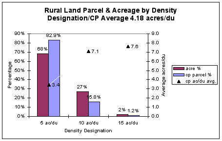
Eliminating the 3 density categories just discussed leaves only the categories discussed in Petitioners' 1/31 Brief: 1 du to 5 acres, 1 to 10 acres and 1 to 15 acres. As set forth in 1/31 Brief at pages 12 - 15, even this range of density is illusory. The data to which SJC has now stipulated shows that the average parcel size in rural land designated 1du/5 is 3.4 acres, that the average parcel size in rural land designated 1du/10 acres is 7.1 acres and that the average parcel size in rural land designated 1du/15 acres is 7.6 acres–not including the impact of existing or future guest houses. (From #260169, by dividing the acreage of each relevant density designation of Total Rural Lands by the number of potential units listed under the column heading "2000 designation"). This means the rural density pattern affords a density of 1du/7.6 acres in the lowest rural density, applicable on 2.1% of rural land (SJC Brief, page 43, line 5), in a CP which will permit an average rural density of 1du/4 acres (existing or future guest houses excluded). SJC admits that sprawl is defined as density greater than 1du/5 acres, while Smith v Lewis, supra, holds that uniform 5 acre designation permits too high a rural average density. CTED admonishes 10 and 20 acre parcels should predominate, which would produce an average rural parcel size of 8 acres. Petitioners request the Board read their 1/31 brief for the full analysis and argument, with maps and charts, regarding the extreme inadequacy of the SJC CP to afford a meaningful variety of rural density.
Petitioner's submit that even if rural lands designated 1du/15 had an average parcel size of 15 acres, rather than of 7.6 acres, this designation offers only the appearance of variety in the rural density scheme because it applies to so little– only 2.1% of rural lands. SJC attempts to knit variety and low density out of thin air–out of parcels too small and too few to matter–crafting a virtual sweater that would keep no one warm. What clears the smoke and mirrors is the average rural parcel size to which the County has stipulated–the rural density of 1du/4 acres–to be made yet more dense with (rental-approved) occupancy of existing and future guesthouses. It should be noted that Eagle Lake's assertion that a variety of rural densities has been provided cites documents ##231429-231432, which improperly included state and federal lands. (Eagle Lake Brief, pg 3, lines 22-23).
SJC states that the Petitioners "deceptively focus on the number of existing parcels and average existing parcel sizes." (line 24-25, pg 42). The table they present, however, refers to CP acreages (not existing acreages) from #260169 and (although SJC does not reproduce it), their chart at #260169 includes CP parcels for these different density categories. Deception is a term that, like a double edged sword, can cut backwards. Petitioners presented the data from #260169 in their 1/31 Brief, page 14, in a graph reproduced below. In Petitioners' graph, not only is acreage data presented, but, unlike SJC's chart (SJC Brief pg 43), the parcel data is presented as well. Parcels are at least as relevant as acreage, since it is through the parcel that the true impact of "density" is experienced in the form of a habitable and occupied residential structure. Focusing on parcels is hardly deceptive; rather, it is informative. The chart presented in Petitioners' brief shows the average parcel size at buildout in each of the 3 rural lands density categories, demonstrating clearly both that the 800 pound gorilla of densities in the County is 1 du/5 acres as well as demonstrating (using the data directly from #260169) that the average density in each of the 3 density categories is substantially below its own density designation, resulting in the overall rural density (sans guesthouses), never mentioned much less defended by SJC in its Brief, of 1 du/4 acres (see #260166 for this SJC-produced number). By choosing to disregard, rather than thoughtfully counter, Petitioners' claims regarding the density impact of the CP, SJC offers a far more credible example of deception. SJC would have the Board believe that it meets the rural density variety requirement of the Act by focusing on acreage and omitting critical parcel information. Further, Petitioners’ have provided information on both existing and CP density conditions–it is the CP density condition, not as SJC states above, the existing density condition, that is the principle focus of this case and of the arguments in Petitioners' 1/31 Brief, which shall not be reproduced here.
The ruling in Smith v. Lewis County, 98-2-0011c, FDO 3313 (April 5, 1999), stated that it is particularly appropriate for lower rural densities to be applied in counties whose rural characteristics can accommodate them. SJC claims to distinguish itself from Lewis County and yet offers no argument to substantiate its position nor to rebut the evidence presented by Petitioners that, like Lewis County, SJC has large parcels which can accommodate lower densities. (SJC Brief pg 42, lines 16-19). Rather, it states flatly that "[r]elatively few large parcels exist in Rural Lands. (##260168, 260170) (SJC Brief, pg 37, line 29) For this proposition it has cited the CP data in #260168 and #260170, to which it stipulated, which show that there are 515 parcels 20 acres or larger in size in just some of the Rural designations (RFF, RR and Other), totaling 20,577 acres. The stipulated data in the table at #260170 shows, under Total Rural Lands, 10,778 acres in 395 parcels 20 to <40 acres and 24,596 acres in 215 parcels 40+ acres. These total 35,374 acres of large parcels which, even if reduced by all 13,012 State and Federal Lands (#260171) amount to 22,362 acres, or 34% of 65,331 total rural acres. (#260166). Petitioners submit that SJC has cited evidence that shows that a significant 34% of the Rural Lands is held in large parcels.
In the next paragraph (lines 21-27), SJC claims that its CP includes a variety of rural densities similar to that approved in Jefferson County, but again fails to demonstrate this claim. Jefferson County included rural lands designated 1du/20 which this Brief has shown exist in SJC in the form of one single Rural Industrial 45 acre parcel on Orcas island, one single 35 acre parcel on Lopez Island, and one uninhabitable parcel on non-ferry served Waldron Island. Later, (pg 48, lines 10-11), SJC states: "[t]here are many reasons why the average density of rural lands in Whatcom or Lincoln Counties may be vastly different from the average density of San Juan County. For that reason, no set standard can be applied." In one case (Lewis County), SJC tries to claim it is different, without discussion of facts. In the next case, (Jefferson County), SJC claims it is similar, again with no factual analysis. Then, SJC claims that regarding other counties, no standard can be used, which would logically mean that one can not compare counties, contradicting its earlier (and ineffectual) attempt to do just that. Rather than offer unsupported blanket statements that SJC is like or unlike any other county, SJC must offer and evaluate specific facts and local circumstances.
Petitioners' 1/31 Brief discusses the relevant authority of ICCGMC v. Island County, 98-2-0023c (CO October 12, 2000) and Smith v. Lewis County, 98-2-0011c (FDO, April 5, 1999). The Island County cases ruling is relevant for the Board's assertion that, as held in Smith v. Lewis, supra, if there are large parcels remaining in a county, the Board will require their preservation. SJC and Eagle Lake assert that the local circumstances in SJC are analagous to those in Island County, where a uniform 5 acre density was upheld. (SJC Brief pg 37 line 5 and Eagle Lake Brief pg 4 line 3). Nothing could be farther from the truth, as Petitioners have previously briefed and argued orally at the November 14, 2000 hearing in this case. The Board held there were not significant large parcels remaining in Island County while there are well over 1000 parcels 20 acres or larger remaining in SJC in rural and resource lands combined, with over 500 in rural lands alone. (##260122-260135, ##260143-260150, #260168, #260170) Large parcels, whether designated rural or resource lands, are relevant where SJC's BOCC will shortly consider redesignating resource lands. (#244509) The location of all large parcels for the county as a whole is pictured on a color map (#260199), originally attached to Petitioners' Motion to Supplement the Record dated January 10, 2001, a black and white reproduction of which is attached as Exhibit D. On the color version of the map one can distinguish rural from resource lands as well as the relative size of the parcels, depicted in shades of color. From the black and white version of the map one sees the overall pattern of all large parcels, regardless of designation; essentially, if the parcel is not "white", it is 20 acres or larger.
Island County had 5% of its land subject to further subdivision, while SJC has 30% of its land subject to further subdivision. Island County had a development regulation which permitted development on no more than 5% of any parcel, (ICCGMC v. Island County, supra at pg 8 and 9) while SJC's so-called conservation subdivision regulations permit development to be scattered over 40% of the parcel.
SJC has ignored the Johnson Brief for November 14, 2000 hearing and Petitioner's 1/31 Brief, both of which present facts and analysis showing that the SJC CP failures to conserve and to buffer resource lands. SJC has stipulated its admission that the CP allows designated forest resource lands to be subdivided from the present average parcel size of 31.4 acres to 17.9 acres in apparent violation of the FDO in this case. (#260166 and Petitioners' 1/31 Brief pages 39-43).
Eagle Lake's Brief asserts that like Island County, SJC lacks forest resource lands of long term commercial significance and that buffering is not required, ignoring the FDO in this case that resource land designation was not at issue, and law cited by Petitioners that designated resource lands must be conserved. Achen v. Clark County, 95-2-0067. Even the balancing of GMA goals cannot include abandoning the conservation of designated resource lands. Hudson & Huber v. Clallam County, 96-2-0031 (FDO April 15, 1997). And finally and most significantly, facts never mentioned by either SJC or Eagle Lake in their conclusory assertions that SJC is analagous to Island County: the Board carefully limited its holding in ICCGMC v Island County to the facts of that case, which not only included the absence of large parcels but also the withdrawal from prosecution of the case by the parties challenging the rural density. The Board's ruling twice emphasized that "[t]his change in position, as well as unique local circumstances, has had considerable impact on our decision." ICCGMC V. Island County, supra at pg 15 and 17. SJC and Eagle Lake's assertion is utterly unwarranted, even misleading, that ICCGMC v. Island County is authority for the proposition that a settlement agreeing to a uniform rural density of 5 acres approved in almost fully subdivided Island County means that an average rural density of 1 du/4 acres, exclusive of existing and future guesthouses, is GMA compliant in San Juan County, where 34% of rural lands are in parcels as large as 20 acres to 100 acres in size.
5. There is no basis for presuming that a significant population shift will occur from rural to urban areas.
SJC admits (SJC Brief, pg 50, line 23-24) that prior to the 2000 amendments, 16% of the county population lives in urban areas, which, although not stated by SJC, refers to the Town of Friday Harbor. As a result of the 2000 Amendments, SJC asserts: "With the redesignation of Eastsound and Lopez Village as UGAs, the number has increased to 25%". One could only wish that a signature on a document would change reality so easily! What SJC wants the reader to imagine is that because there are now 2 new UGAs, new residents will move there. This in spite of the common knowledge that 92% of the building permits for SFR’s for the last several years are being issued for rural areas of the county. New residents are not moving to San Juan County to live in a UGA, not at today’s land prices, and changing the name on the sign as you enter Eastsound is not going to change that. "By the year 2020, the county expects 35% of the population to live in urban areas." There is no basis for this expectation. Making more du’s available in UGA’s may help, but there is nothing in the CP that directs population to UGAs. There is nothing in the UDC that ties the issuance of a building permit to the Vision Statement, to the land use policies of the CP, or to the intent of the CP. There might as well not be a CP vis-a-vis goal 1 of the Act as far as the Permit Center is concerned.
Further, the Act generally implies that new development will come by subdivision, which might be true in King County, but is certainly far from the case here. If as in a largely built-out urban county, the only subdivision occurs in UGAs, then the Act and that county’s CP may well work together. In San Juan County, where there are thousands of non-conforming rural parcels that are both vested and undeveloped, there is no way, short of a very innovative strategy, where a building permit would not be issued at any time to a landowner with an undeveloped parcel. With apologies to the "Field of Dreams", the shift to urban predicted by SJC may be a case of "if you build it, they will not come." Dreams may in fact be the correct characterization here. SJC asserts that "This shift will slow the rate at which rural lands are developed" but offers no explanation, much less public policy that would accomplish this in the face of substantial evidence to the contrary.
6. SJC asserts (V, 10) that "aspects of rural character have been studied and considered", quietly omitting that the key density "aspect" was never studied by the BOCC.
On page 51 of SJC’s Brief, SJC asserts that, in contradiction to Petitioners, "a review of the record shows that each of these topics has been evaluated, discussed, studied, analyzed and considered in text, maps and other data." Of the several topics mentioned by SJC in a table on page 51, "development potential" is listed. Several maps are indicated with index numbers, along with index numbers referencing the "Analysis of Proposed Urban Growth Areas (UGAs), Activity Centers and Residential Activity Centers" along with the Appendices to this Analysis. Aside from the fact that the titles of these documents do not suggest county wide population forecasting data, and in spite of the fact that the documents in fact do not contain county wide population forecasting data tied to the density designations, the county cites them as containing the information necessary to complete the "consideration" as described above. In fact, only after Petitioners established in arguments and briefs to the Board that state and federal lands were improperly included in CP data on rural lands, was a stipulation agreement reached regarding CP data, entered on January, 12 2001 (##260165-260171), and the true nature of the density implications of the CP was finally revealed. This nature was discussed at length in Petitioners' January 31, 2001 1/31 Brief and, curiously, hardly mentioned by SJC in its 20 February 2001 Brief. A phone call to Dylan Stephens, Senior GIS Analyst for San Juan County on February 18, 2001, revealed that it would be reasonable to estimate that it would take about a week of work to produce the tables of data that were the basis for the stipulation (Declaration of Joe Symons, February 19, 2001, attached). The question that comes to mind is: since Petitioners had been asking for data describing the density inherent in the CP for many months during the remand period prior to the final adoption of the 2000 Amendments, and yet it was not able to be produced until a month after the Board’s November 2000 Order, even though it might have taken about a week (and likely less) to develop and would have been of substantial assistance to the BOCC, why wasn’t it produced earlier? We can only speculate that the BOCC did not ask for it, and we can only speculate as to why they did not ask for it. One logical conjecture is: they didn’t care to know because it would not have influenced their decision. Their minds had been made up months earlier: they had decided simply to meet the minimum density obligations imposed by the 1999 FDO. Anything else was irrelevant. For SJC to thus claim that "development potential" could have been reasonably "evaluated, discussed, studied, analyzed and considered" without this data, is specious.
7. SJC claims that the County "has met and exceeded the public participation standards required by the Act," despite failing to notify the public of the true density implications of the CP during the remand period.
On page 70 of the SJC Brief, SJC claims that "When viewed in its entirety, the CP and UDC meet the letter and the spirt of the Act." Part of the letter of the Act is the public participation goal, and part of the spirit of the public participation goal of the Act would be that, when it comes to crafting a CP density configuration with all that it implies vis a vis fiscal and environmental impacts, merely holding a few public hearings where no substantive information on these topics was offered to the public, is grossly insufficient to meet this standard.
8. Relief Sought
The FDO in this case invalidated densities greater than 1 du/ 5 acres in rural lands, 1 du/10 acres in agricultural resource lands and 1 du/20 acres in forest resource lands. Procedural rules put extreme constraints on the November 14, 2000 Hearing on Recision of Invalidity and Compliance/Invalidity, allowing only a facial review. The Order on Recision of Invalidity and Compliance/Invalidity stated:
Here we had to balance the County’s request to deal only with the recision of invalidity with the very reasonable request of the Challengers to review the entire County action and perhaps impose new or different invalidity determinations resulting from the County’s actions during the remand period. The provisions of the 2000 amendments extended beyond the four County actions to remove invalidity and included, at least arguably, merely a shift in emphasis by the County without addressing the fundamental reasons for the original invalidity. The scope of the response to the noncompliance and invalidity in this case makes it very difficult to fairly determine the issues piecemeal. There are serious questions about whether the County has achieved compliance, and whether new invalidity ought to be found, on a number of issues, but we are simply not able to address those issues until the January 17, 2001, hearing. [Deferred to March 6, 2000 by agreement of the parties.] The decision to wait results from both the speed under which this order must be issued as well as the lack of completeness by all sides on some of the reserved issues. This is not a criticism to any of the parties because the time constraints they labored under were probably even more significant than the one under which we are laboring.
Order of Recision page 6, (emphasis added.)
Now the issue of compliance and invalidity of rural density is again before the Board, this time with stipulated data which became available only mid-January, 2001. Even in November, 2000, not to mention at the Hearing on the Merits held June 15, 1999, the number of acres in many areas of the county, the meaning of various density designations and other basic facts essential to an evaluation of the adequacy of the rural density pattern, was unknown even to the County. For the first time, this Board–and the citizens and administration of SJC–have access to accurate data on rural density under the CP. Further, the October 2000 Amendments were accompanied by the SJC BOCC's action to initiate reconsideration of all resource lands. Composition of a rural pattern of densities that conserves resource lands is impossible without knowing where such resource lands are situated.
Petitioners' respectfully submit that the evidence presented shows that the rural density designations are seriously flawed and that, upon its consideration, the Board will be left with the firm and definite conviction that a mistake has been made by the County in its attempt to stop sprawl, to provide a variety of rural densities, and to conserve rural character and resource land. Further, the facts show that these goals of the Act have been thwarted by an egregious margin of error, that the CP would promote sprawl and the destruction of resource lands and rural character. This substantial interference warrants invalidation of densities in rural and resource lands. Remanding the CP for further work would enable the presentation of the new data to the public for the first time, and would enable the use to its full potential of sophisticated GIS planning tools to refine and craft a compliant CP.
Petitioners' request relief as follows:
1. That the density designations in rural lands be invalidated and remanded for analysis to ensure a true variety of rural densities and to preserve rural character;
2. That any reconsideration of resource lands be completed before rural density redesignation or further subdivision of rural lands;
3. That the CP and UDC be remanded for full analysis, using GIS and other reasonably available data, of SJC's local circumstances and of the costs and impacts of development; and for the subsequent development of a pattern of rural and resource land densities that buffers resource lands and preserves existing large parcels (rural and designated resource), critical areas, rural character, and surface and ground water quality and quantity, in accordance with the GMA;
The Petitioners respectfully request remand and an expanded order of invalidity pending completion of the planning work set forth in the requested relief, work necessary to avoid the present substantial interference–effected by the SJC CP and UDC–with the goals of the Act.
Dated: This 26th day of February, 2001.
Maile Johnson Joe Symons
Lynn Bahrych WSBA # 15417